Import Package
Use Import Package to import survey data.
There are a number of data types you can import:
-
Transfer Package (extension *.vnar) - This is the most extensive type, it can contain all Shapes
 A geometric entity or a collection of such entities. Each entity is described by basic geometry such as a point, a line or an arc. Examples of shapes are: Route, Centerline, Waypoints, Fix Set, Dump Boxes, Progress Grid Model, Designs, etc., Models, complete Projects and Geodetic
Regions.
A geometric entity or a collection of such entities. Each entity is described by basic geometry such as a point, a line or an arc. Examples of shapes are: Route, Centerline, Waypoints, Fix Set, Dump Boxes, Progress Grid Model, Designs, etc., Models, complete Projects and Geodetic
Regions. -
Update Package (extension *.prup) - This Package contains updates for your Progress Grid Model
The Grid Model that will show the current levels in your working area. It is updated by survey updates and by your head(s) (Dredgehead, bucket, WID bar, plough, etc.) or data for a Progress Fix Set A shape file that can contain fixes and/or targets. Targets are points (positions defined by an X and an Y co-ordinate) to be used in VOSS RT, for operators to perform certain actions on each target. For example, place a block, drop an anchor, install a vertical drain. In VOSS RT, at the moment of installation, automatic or manually a fix can be logged, that contains the actual co-ordinates, date & time and other parameters. file. -
Third Party XYZ (extension *.xyz or zip)- Update of the levels for the Progress Grid Model
A type of DTM that is made manageable through sampling measured points into a regularly spaced raster, allowing fast and conditional access. Considered to be a secondary data set; since no original points are kept... -
PDS Update Grid (extension *.dtm or zip)- Update of the levels for the Progress Grid Model.
-
View Layout Package (extension *.vlp)- Import View Layout(s).
Where to store Import Packages?
On small units with only one Survey PC, you may either use a USB pen drive or make a folder called SURVEY UPDATES if you receive updates via email.
On bigger Van Oord vessels with a server and various Clients, a folder on the Common drive, which is accessible from the ship's email, will exist.
To import a Package:
 MENU > Import Package:
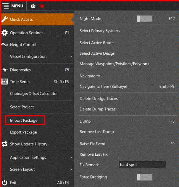
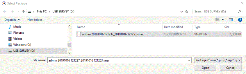
Select the drive and
folder where the import package is stored and click Open
Import Transfer Package
Transfer packages have file extension *.vnar.
Project An area of work that is defined and described by its tasks and/or its data sets. A project is an integrated part of any one (1) Geodetical Region. data
travels from the site office to equipment via the
medium Transfer Package. The project surveyor compiles a number of entities
necessary for the job, for example a design, centerline An aiding line used in the construction of infrastructure. It usually corresponds to the center of that structure.,
progress grid model and dump boxes.
In case the equipment starts working on a project for the first time,
the Transfer Package generates this new project (and Geodetic Region if
need be) on the SDM Survey Data Manager - the database that manages and carries the total set of your data. during the import process.
A Window will open showing information of the Transfer Package:
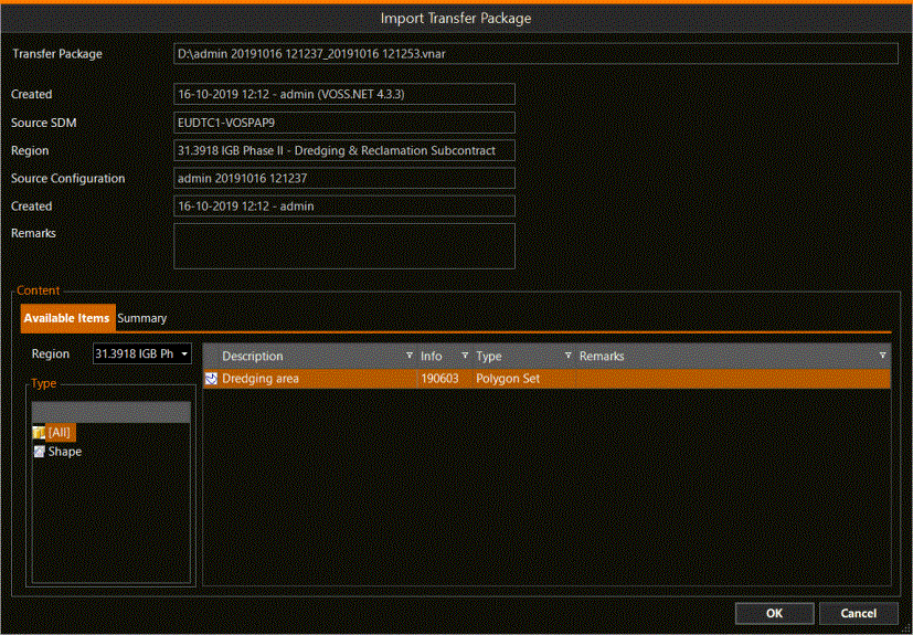
The user can see which items are inside the Transfer Package and in which (Geodetic) Region they will be stored.
In the example above we see it is a Polygon Set A Shape file containing one or more Polygons named Dredging area with date 190603.
Click OK to start importing.
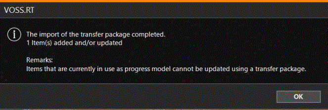
Wait until VOSS RT shows the message that the import has been completed, as below:
Select the items imported with a Transfer Package for use
When you import items with a Transfer Package, they are stored in the SDM of your equipment. They are not yet used in VOSS RT. Depending on what type of items you have imported and what their purpose is, they need to be selected in different locations of VOSS RT:
Designs
Design model (type: TIN Triangulated Irregular Network - a vector based data structure that describes a surface, made up of irregularly distributed 3D nodes that define constraints. or Grid A type of DTM that is made manageable through sampling measured points into a regularly spaced raster, allowing fast and conditional access. Considered to be a secondary data set; since no original points are kept.. Model) that you
need to excavate, dredge, fill or dump to: select it as a Design.
See: Design and use Add Design.
If it is a Design Model that is just to be shown as information, for example a Design on which another piece of equipment is working to: select it as a Supporting Shape.
See: Supporting Shapes and use Add Supporting Shapes from SDM.
Routes
Route Routes are aiding lines used in the construction of infrastructure. They usually correspond to the center or a standard offset to the center of that structure. A Centerline can be a Route. A Pipe or Pipeline can also be a Route. (type: Centerline or pipeline) which
is to be used as your main
reference line to which Chainage/KP
and Offset are calculated to: select it in Main Shapes as Active Route.
See: Select or change Active Route.
If it is not to be used as your Active Route, select it as Supporting Shape.
See: Supporting Shapes and use Add Supporting Shapes from SDM.
Avoidance Areas
Avoidance Areas (type: Avoidance area) can only be selected at Main Shapes.
See: Select or change Avoidance Area(s).
Dump Boxes
A Dump Boxes shape which you want to use for dumping, can be selected under Main Shapes: Select or change Dump Boxes.
To just show it, not being able to select boxes for dumping, add it at Supporting Shapes.
See: Supporting Shapes and use Add Supporting Shapes from SDM
Grid model
If this Grid Model is meant to be updated by survey updates and passes of your dredging head(s), it should be selected as Progress Grid Model under Main Shapes.
See: Select or change Progress Grid Model.
If it is a model in an area where no work takes place, for example a grid model that covers a sailing route, it should be selected as Supporting Shape.
See: Supporting Shapes and use Add Supporting Shapes from SDM.
Fix Set
A Fix Set is, for example, used by Vertical Drain Installation Rigs, Rapid Impact Compactors or for block placing. It contains the target locations and it is used to store the Fixes as created during operations. The Fix Set you need to work with, can be selected in Main Shapes.
See: Select or change Progress Fix Set.
Production Model
Production
Model (type: Grid Model) is used with suction dredgers like a TSHD Trailing Suction Hopper Dredger. A Production
model can only be selected under Main Shapes.
See: Select or change Production Model.
Checkerboard
If you want to use a Checkerboard (type: Dump boxes) so that it is updated after every dump, select it as Main Shape.
See: Active Checkerboard.
To just show it, not being active, add it at Supporting Shapes.
See Supporting Shapes and use Add Supporting Shapes from SDM
Import Update Package
Update packages have file extension *.prup. These Packages contain updates for your Progress Grid Model or data for a Progress Fix Set file. The Update Package files are produced by the VOSS.NET software. Normally, updates for the Progress Grid Model will contain time and date. This means that if your equipment has been changing the Progress Grid Model after the survey was performed, the grid will not be overwritten.
The Update Package can also contain an update of a Fix set. This Update is for example used by Vertical Drain Installation Rigs, where fixes performed by other rigs can be updated.
Import Third Party XYZ
These files have extension *.xyz or *.zip. Third Party updates contain updates for your Progress Grid Model. They do not contain date and time so they will overwrite your Progress Grid Model everywhere the Update contains data.
XYZ points are individual points. VOSS RT will interpolate between the points by making a temporary TIN model. To do this VOSS RT needs to know the Maximum Triangle Side. Ask the surveyor who sent the update for advice on Triangle Sides. VOSS RT will by default come up with a Maximum Triangle Side of 10 meters, this will make sure it's big enough to perform the update. However, this can lead to undesired interpolations.
Reduce the Triangle Side and click Apply and check if you still see data in the Preview. Use the smallest Triangle Side where you still see data in the Preview.
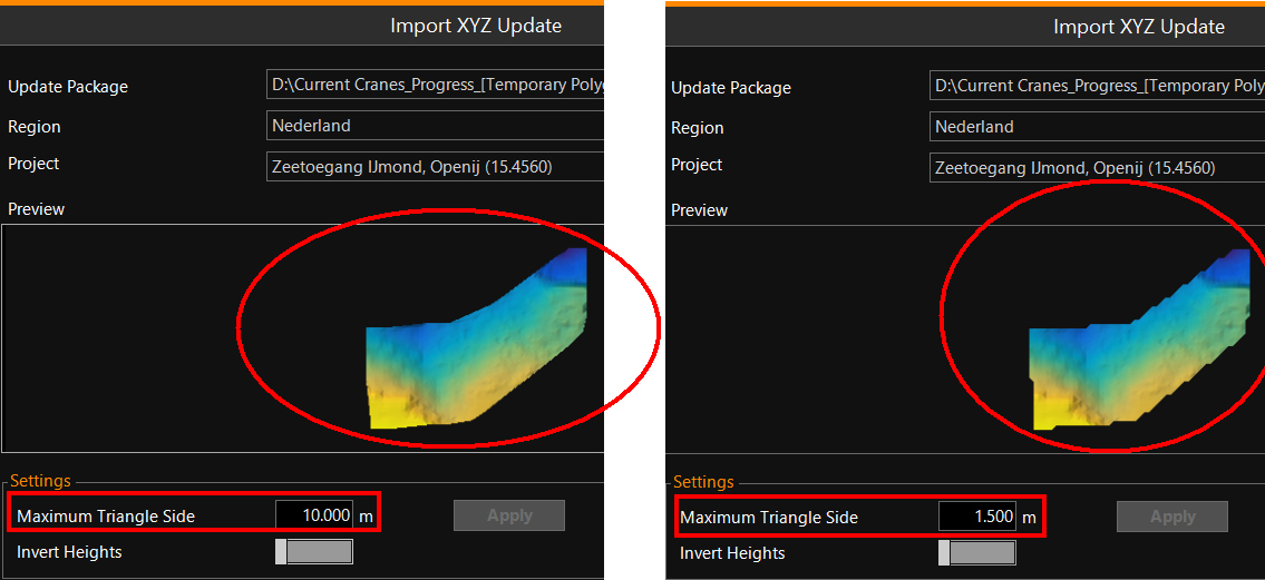
Sometimes it can happen that the sign of the data is the other way round than VOSS RT requires, which is heights are positive and depths are negative. If the result is wrong, do the Update again with the Invert Heights switched on.
Import PDS Update Grid
These files have extension *.dtm or *.zip. These files come from the PDS software used by most Van Oord Multibeam survey vessels. These files may contain date and time, if not, everywhere where the update contains data it will be overwritten the Progress Grid Model.
Import View Layout Package
See: Import View Layout Package