Welcome to VOSS RT
How to use this help
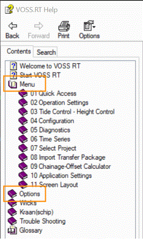
The main items as seen when starting up VOSS RT can be found under 'Menu'.
Most other options as available in the various windows can be found under 'Options'.
You can also type a term in the Search box and a list of all related pages will be shown:
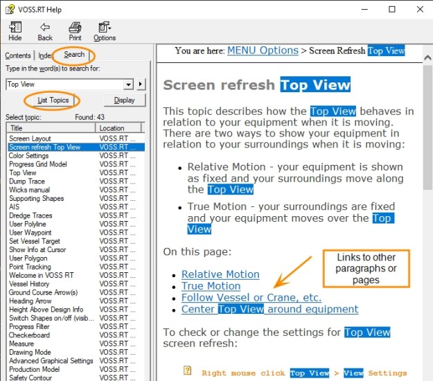
In the Help you will find many links that will take you to other parts of the help.
To go back to the previous page use 'Back' at top left.
For Wicks operators: view Wicks manual or Wicks handleiding
Voor kranen en kraanschepen in het Nederlands: Kraan(schip) Paans Van Oord
 Good to know
The info below explains some of the commonly used terms to get a better understanding of VOSS RT.
Meaning of VOSS RT
VOSS RT means: Van Oord Survey Software Real Time
What is VOSS RT
VOSS RT is a software package that provides assistance for navigation and operation activities for (construction) vessels and land based plant. VOSS RT was built by the software developers of Van Oord's Survey Department.
Equipment
In VOSS RT, Equipment is the collective name for all marine and land machinery provided with positioning (and attitude devices).
Equipment type
VOSS RT distinguishes between different Equipment In VOSS RT Equipment is the collective name for all marine and land machinery provided with positioning (and attitude devices). types. Depending on
your Equipment type, VOSS RT offers you different options and features.
In VOSS RT Equipment is the collective name for all marine and land machinery provided with positioning (and attitude devices). types. Depending on
your Equipment type, VOSS RT offers you different options and features.
At present VOSS RT offers the following Equipment types:
-
Auxiliary Equipment
-
Backhoe
-
Barge Unloading Dredger
-
Construction Vessel
-
Cutter Suction Dredger
-
Excavator
-
Flexible Fall Pipe Vessel (FFPV)
-
Hopper Barge
-
Horizontal Drain Trencher
-
Multicat
-
Pre-Drill Rig
-
Rapid Impact Compactor
-
Shallow Water Pipe Lay Barge
-
Side Stone Dumper
-
Site Office
-
Spray Pontoon
-
Suction Dredger
-
Trailer Suction Hopper Dredger (TSHD)
-
Tug
-
Vertical Drain Installation Rig
-
Vibroflotation Rig
-
Water Injection Dredger (WID
Water Injection Dredger - removes (soft) sediments by injection of water in the sediments via a jet bar.) -
Wire Crane
Body, arms and heads
Equipment in VOSS RT always has a Body. This is the main part of the Equipment; for example the hull of a vessel or the crane house of an excavator. The positioning antenna(s) (and heading and attitude sensors) will always be present on the body.
Further, Equipment can have one or more arms. Examples of arms are: the suction pipes and drag head of a Trailer Suction Hopper Dredger or the boom, stick and bucket of an excavator.
At the end of an Arm is the head. Examples of heads are the drag head of a Trailer Suction Hopper Dredger, the bucket of an excavator or a plough.
Surface Model
Surface
Model: Surface layer, most commonly a Grid A type of DTM that is made manageable through sampling measured points into a regularly spaced raster, allowing fast and conditional access. Considered to be a secondary data set; since no original points are kept.. or TIN Triangulated Irregular Network - a vector based data structure that describes a surface, made up of irregularly distributed 3D nodes that define constraints. model which can be selected and used as bathymetric/topographic
reference or as a design.
Shape
Shape:
All other entities like Centerline An aiding line used in the construction of infrastructure. It usually corresponds to the center of that structure.,
Dumpboxes Virtual boxes placed inside a working area. They are used as a guide for working vessels or
Waypoints Set of coordinates that identify a point in physical space. Waypoints for navigational use are usually defined in two dimensions (e.g. latitude, longitude, or Easting, Northing).
Geodetic Region
A Geodetic Region is an area with its own unique geodetic system.
Most positioning systems are satellite based systems and they produce
co-ordinates in a worldwide or global co-ordinate system (WGS-84). As
the earth is not a perfect sphere but more an irregular rugby ball or
a potato shape, every country has its own way to get from global co-ordinates
to local Eastings and Northings to have the best fit for that area. How
to go from global co-ordinates to local co-ordinates is described by
the geodetic system. Larger countries are even subdivided into different
zones. All Surface Models and Shapes A geometric entity or a collection of such entities. Each entity is described by basic geometry such as a point, a line or an arc. Examples of shapes are: Route, Centerline, Waypoints, Fix Set, Dump Boxes, Progress Grid Model, Designs, etc. that have the same geodetic system
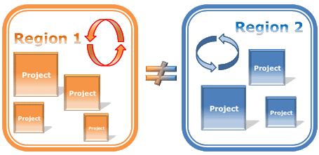
can be used in a Project An area of work that is defined and described by its tasks and/or its data sets. A project is an integrated part of any one (1) Geodetical Region.
together because they will be in the same Geodetic Region. If all shapes
and models in one geodetic region are apples, they can never be combined
with the pears of a neighboring region. The software will ensure that
this is impossible.
Project
A project in VOSS is a collection of Surface Models, Shapes and Color Tables. These Surface Models, Shapes and Color Tables are stored in its Geodetic Region. A project is in fact a filter that only shows the items from that Geodetic Region that are relevant for that Project. Some items will be used by various projects in that same region, for example all navigation buoys in the waters of Dubai.
Normally, various Projects exist in a Geodetic Region. Projects can be in different locations like, for example, Maasvlakte 2 and IJmuiden in the Netherlands, or it can be that various projects exist at the same location but they handle completely different tasks or disciplines.
SDM
SDM stands for Survey Data Manager. This is the database that carries all data.
Meta data
Meta data
is information about data. All items in the SDM Survey Data Manager - the database that manages and carries the total set of your data. have a Description, a type
(grid model, centerline, polygon
set, etc.), they may have a version number and may have a remark.