Drawing Mode
With the Drawing Mode you can define, edit and delete your self made
Waypoints Set of coordinates that identify a point in physical space. Waypoints for navigational use are usually defined in two dimensions (e.g. latitude, longitude, or Easting, Northing), Polylines and Polygons.
Only Waypoints, Polylines and Polygons defined by you, the user, can be edited or deleted.
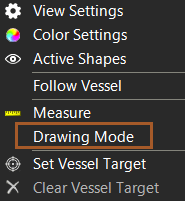
Start Drawing Mode
 Right mouse click
Top View > Drawing Mode
Right mouse click
Top View > Drawing Mode
|
|
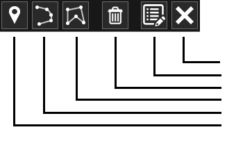
Delete User Waypoint, Polyline or Polygon
Only Waypoints, Polylines and Polygons can be deleted. To Delete a User
Waypoint, Polyline or Polygon Plane figures that are bounded by a closed path. first Start Drawing Mode.
There are two ways to Delete:
-
Look up the item in the Top View, click on it and click the Delete button
-
Click on the List button, choose the required TAB: Waypoints or Polyline and Polygons, click on the item. Click Zoom to check if it is indeed the item you want to remove and click Remove
If it's not possible to Delete the item you want to Delete, it is not
a User Item but a Shape A geometric entity or a collection of such entities. Each entity is described by basic geometry such as a point, a line or an arc. Examples of shapes are: Route, Centerline, Waypoints, Fix Set, Dump Boxes, Progress Grid Model, Designs, etc..
In this case you can switch that Shapes off. See: Switch Shapes on/off (visible/unvisible)