Multi Tide
With Tide Sensor as height source, the Height Control dialogue can be configured as Multi Tide.
This option can be applied when working, for example, on a river with several tide stations along the route.
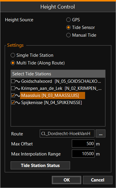
Tide stations which play a role in the calculation can be selected,
as well as a Route Routes are aiding lines used in the construction of infrastructure. They usually correspond to the center or a standard offset to the center of that structure. A Centerline can be a Route. A Pipe or Pipeline can also be a Route. along which the stations are located. For this it is
important that the surveyor has entered the correct geographical locations
of the Tide Stations in the Control Center of VOSS.NET. The tide value
that will be applied in VOSS RT is a linear interpolation between the nearest
two tide stations based on distances.
Routes are aiding lines used in the construction of infrastructure. They usually correspond to the center or a standard offset to the center of that structure. A Centerline can be a Route. A Pipe or Pipeline can also be a Route. along which the stations are located. For this it is
important that the surveyor has entered the correct geographical locations
of the Tide Stations in the Control Center of VOSS.NET. The tide value
that will be applied in VOSS RT is a linear interpolation between the nearest
two tide stations based on distances.
Max Offset - The distance perpendicular to the route wherein a tide value will be calculated, outside this limit a computation warning will occur.
Max Interpolation Range - This affects the calculation in two ways. First the interpolation range, this is the greatest distance along the route in between any of the tide stations. In this example the distance between station Spijkenisse and Maassluis is 10.018 m. With the interpolation range set to 10.500 m the tide can be calculated anywhere in between. Secondly it is the set distance of where the tide value remains valid beyond the first or last station in the range. Practically no interpolation takes place, but it holds the value of the nearest station.
Tide Station Status - Will show you the health of all available stations. In Multi Tide mode both stations in use are indicated green (if good).
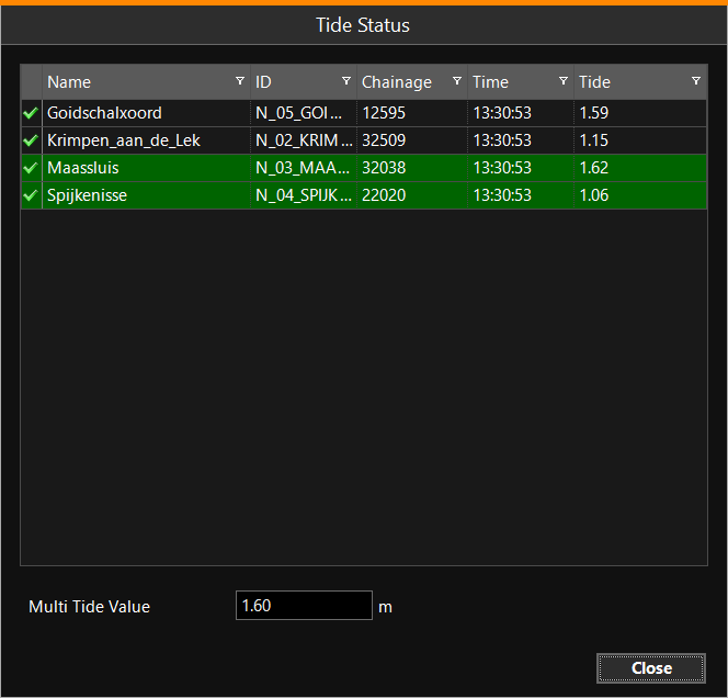
In the example above, the Multi Tide Value is 1.60 m, calculated from stations Spijkenisse and Maassluis. This implies the equipment is located (very) close to Maassluis: